


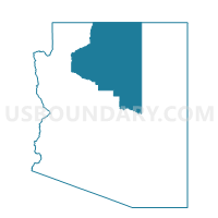
Kaibeto Voting District, Coconino County, Arizona
About
Outline

Summary
| Unique Area Identifier | 523730 |
| Name | Kaibeto Voting District |
| County | Coconino County |
| State | Arizona |
| Area (square miles) | 515.29 |
| Land Area (square miles) | 515.21 |
| Water Area (square miles) | 0.08 |
| % of Land Area | 99.98 |
| % of Water Area | 0.02 |
| Latitude of the Internal Point | 36.64029960 |
| Longtitude of the Internal Point | -111.11337010 |
Maps


Graphs
Select a template below for downloading or customizing gragh for Kaibeto Voting District, Coconino County, Arizona


Neighbors
Neighoring Voting District (by Name) Neighboring Voting District on the Map
- Coppermine Voting District, Coconino County, AZ
- Inscription House Voting District, Coconino County, AZ
- Lechee Voting District, Coconino County, AZ
- Navajo Mountain Voting District, Coconino County, AZ
- Tonalea North Voting District, Coconino County, AZ
- Tuba City North East Voting District, Coconino County, AZ